
Brazil identifies flood-prone areas of cities
The study combined models that predict urban expansion and land-use changes with hydrodynamic models, and the results were validated using actual data for São Caetano do Sul, a city in metropolitan São Paulo.
Scientists affiliated with the National Space Research Institute (INPE) in Brazil have combined models that predict urban expansion and land-use changes with hydrodynamic models to create a methodology capable of supplying geographical information that identifies flood-prone areas of cities, especially those vulnerable to the impact of extremely heavy rainfall.
The groundbreaking study was based on data for São Caetano do Sul, a city in metropolitan São Paulo, but the methodology can be used by other cities to devise public policies and make decisions in addressing the impacts of these phenomena to avoid deaths of residents and destruction of buildings and infrastructure.
FAPESP funded the study via two projects (20/09215-3 and 21/11435-4). Preliminary results are reported in an article published in the journal Water. They were part of the Ph.D. research of Elton Vicente Escobar Silva, the first author of the article and a researcher at INPE.
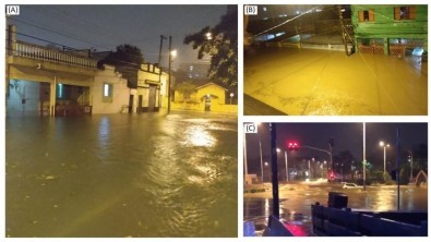
In partnership with the Federal University of Paraíba (UFPB) and the Federal University of Rio Grande do Sul (UFRGS), and with local bodies, the researchers “tested” the modeling methodology using civil defense data for the city relating to a flood that occurred on March 10, 2019, when three people drowned and the floodwaters reached a depth of almost 2 meters in several streets.
“I’ve worked with modeling for years, focusing on changes in land use and cover in urban areas. I wanted to combine this with flood simulation. The opportunity arose in connection with Elton’s project,” Cláudia Maria de Almeida, joint first author of the article and Silva’s thesis advisor, told Agência FAPESP. She is also a researcher at INPE, and she heads the institute’s urban remoting sensing unit (CITIES Laboratory).
“The study innovated by combining hydrodynamic modeling for urban areas with the complexity of the underground runoff drainage network, and by using real data to calibrate and validate the model. We combined very high-resolution spatial imaging and deep learning. All this is linked to big data and smart cities,” she said.
Discussion of smart cities began in 2010, initially involving technological issues such as integrated traffic light control systems and bus stops with Wi-Fi. Sustainability and quality of life for residents have been included more recently.
According to the United Nations, the world population reached 8 billion in 2022, with 56% living in urban areas. The population is expected to rise to 9.7 billion by 2050, with 6.6 billion (68%) living in cities.
Cities are currently expanding at twice the rate of population growth. In the next three decades, urban areas worldwide are set to total more than 3 million square kilometers, equivalent to the territory of India.
City planning is not advancing at the same pace. For example, rampant urbanization incurs changes in land use and cover, expands impermeable surfaces, and alters hydrology. In conjunction with the higher frequency of extreme weather events due to climate change, this exposes cities to flooding and landslides in the rainy season.
Cross-tabulation
For hydrodynamic modeling, the researchers used a software package called HEC-RAS (Hydrologic Engineering Center’s River Analysis System), which simulates water flow and surface elevation, as well as sediment transport.
To identify flood-prone areas, they used two digital terrain models (DTMs) with different spatial resolutions of 0.5m and 5m. A DTM is a mathematical representation of the topography of the Earth’s surface, excluding all vertical objects. The model can be manipulated by computer programs and is typically visualized as a grid in which an elevation value is assigned to each pixel. Vegetation, buildings, and other characteristics are digitally removed. In this study, the researchers used four supercomputing intervals (1, 15, 30, and 60 seconds) in their analysis of the simulations.
The best results were obtained from the simulations with a spatial resolution of 5m, which displayed maps with the highest coverage of flood-prone areas (278 out of 286 points, or 97.2%) in the shortest computation time. They identified the potential for flooding in areas not detected by civil defense authorities or citizens of São Caetano do Sul during actual flood events.
“We set out to create a methodology to support decision-makers. We simulated projected land-use changes several years ahead and their impact on the network of watercourses. On this basis, it’s possible to run simulations with scenarios. An example would be specifying millimeters of rain in a given timeframe to predict the impact on an area of a city in terms of flooding. Public administrators can use this capability to make decisions, avoiding economic damage as well as loss of life,” Silva said.
The researchers stressed the need for cities to update their databases for this type of analysis, as did São Caetano do Sul. “The model works with and is fed by data. It’s important for cities to have up-to-date information, including records relating to extreme cases, such as major floods and inundations,” Almeida said.
São Caetano do Sul is part of a dense conurbation that encompasses São Paulo city as well as the neighboring cities of Santo André and São Bernardo do Campo. It has had many floods and inundations – 29 between 2000 and 2022 alone, according to the researchers.
On the other hand, it ranks first among all 5,570 municipalities in Brazil for sustainability based on the Sustainable Development of Cities Index – Brazil (IDSC-BR), part of a series of reports produced by the United Nations Sustainable Development Solutions Network (SDSN) to monitor implementation of the Sustainable Development Goals (SDGs) in member countries.
With some 162,000 inhabitants, it has a comprehensive wastewater treatment system connected to 100% of homes. Almost all urban dwellings (95.4%) are located on public streets with trees, and a reasonably large proportion (37%) are on adequately urbanized streets (paved and with sidewalks, curbs, and drains), according to IBGE, Brazil’s census and statistics bureau.
 How to resolve AdBlock issue?