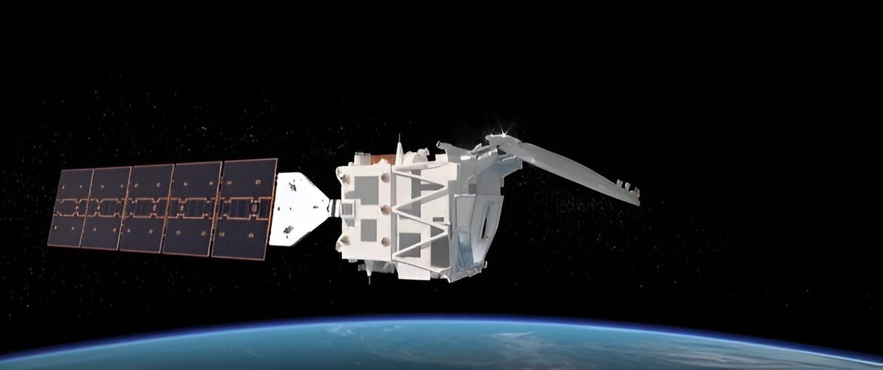
Jeroen Rietjens is pictured in the Goddard cleanroom with the PACE satellite. He expressed his pride at being able to pose with the fully assembled and tested PACE satellite, which hosts their small SPEXone instrument. The instrument is neatly wrapped in grey thermal blankets and still has the red radiator cover in place. Rietjens finds it surreal to realize that in just a few months, it will be staring at the Earth and collecting multi-angle spectro-polarimetric data. This data will enable scientists to infer the amount and type of aerosols in the Earth's atmosphere, contributing to a better understanding of the effects of aerosols on climate. The credit for the photo goes to NASA/Denny Henry.

NASA set to launch new satellite that helps unravel mysteries about clouds, aerosols

NASA will launch a new satellite named PACE, which aims to unravel mysteries surrounding clouds and aerosols. Scientists hope to gain a deeper understanding of cloud formation and the impact of tiny particles known as aerosols by studying the behavior of light and optics in the atmosphere. The PACE mission will observe airborne particles, including sea salt, smoke, pollutants, and dust to provide important insights into their interactions with light. This data will help answer crucial questions about how aerosols affect cloud formation and distinguish between ice clouds and liquid clouds, which is essential for better understanding changes in climate and air quality.

The PACE mission will use two advanced polarimeters named HARP2 and SPEXone to study aerosols and clouds. Once launched, the mission will observe the Earth and collect data on the chemical composition, movement, and interaction of these atmospheric components. These cutting-edge instruments capture light properties that are both visible and invisible to the human eye, such as color and polarization, respectively. Polarization is not something we can perceive with our eyes, but it can be seen through sensors like those on PACE. If we could see polarization, rainbows would be everywhere in our view of the world, according to Kirk Knobelspiesse, who leads the polarimetry efforts at NASA's Goddard Space Flight Center in Greenbelt, Maryland.

Light from the Sun travels in all directions like a wave, which is known as unpolarized light. However, when it encounters an object such as a cloud or aerosol particle, the movement of light can become more concentrated in one direction, creating polarized light. This unique behavior of light can provide valuable information for scientists studying aerosols and water droplets in the atmosphere. By using polarimeters, researchers can measure the angle at which the light is polarized and gather data on the size, makeup, abundance, and other characteristics of particles present in the air.

The polarimeters, HARP2, and SPEXone complement each other in measuring different aspects of Earth's atmosphere. PACE will provide high-quality data from multiple vantage points, scanning Earth every two days to gather information on aerosols and clouds. Measuring aerosol properties is essential to understand their impact on climate. They reflect and absorb light, affecting how much energy reaches Earth's surface and influencing cloud formation. PACE data will provide valuable insights into these relationships and improve air quality for humans, according to Professor Loría-Salazar from the University of Oklahoma's School of Meteorology, who is an early adopter of PACE data integration into practical science applications.

Scientists can not only identify aerosols but also decipher their impact on air quality using PACE. The polarimeters on board PACE will also contribute to our understanding of Earth's climate. By incorporating atmospheric data from PACE into supercomputer models, scientists can replace current estimations used to fill data gaps with more accurate measurements. Kirk Knobelspiesse hopes that this data will reduce uncertainty in models and lead to better predictions for how our climate will evolve in the coming decades and centuries.

How #EarthCARE mission advances our understanding of clouds, aerosols, radiation

Introduction 

In the realm of climate research and weather prediction, one of the biggest uncertainties lies in the relationship between clouds, aerosols, and radiation. To tackle this challenge and gain valuable insights into these complex interactions, the European Space Agency (ESA) is preparing to launch the Earth Cloud Aerosol and Radiation Explorer (EarthCARE) mission. This groundbreaking mission aims to shed light on key scientific questions and provide novel observations to enhance our understanding of Earth's atmosphere. By employing state-of-the-art instruments, EarthCARE will revolutionize our knowledge of clouds, aerosols, and radiation and improve supercomputer models of the climate and weather. In this article, we delve into the four cutting-edge instruments onboard EarthCARE and explore how they contribute to unraveling the intricate processes that govern our climate system.

ezgif.com resize 2 3fb64

Atmospheric Lidar: Illuminating the Vertical Profile

One of the key instruments onboard EarthCARE is the atmospheric lidar, an advanced system that utilizes light detection and ranging (lidar) technology to measure the vertical profile of aerosols and clouds in Earth's atmosphere. By emitting light pulses and analyzing the reflected signals, this unique lidar provides precise information about the distribution and properties of aerosols and clouds. It reveals crucial details such as their altitude, thickness, optical properties, and aerosol type. These observations are essential for improving supercomputer models of the climate and understanding the role of aerosols and clouds in Earth's energy balance.

The atmospheric lidar's ability to accurately measure the vertical profiles of aerosols and clouds along the EarthCARE track grants researchers invaluable insights into the behavior of these atmospheric phenomena. Armed with this data, scientists can enhance our understanding of how aerosols and clouds impact climate and weather patterns.

Cloud Profiling Radar: Peering into the Internal Structure

Another instrumental component of EarthCARE is the cloud profiling radar, provided by the Japanese Space Agency (JAXA). Operating in the millimeter-wavelength range, this radar enables EarthCARE to observe the internal structure of clouds. By penetrating through clouds and light precipitation, it provides detailed information about their vertical structure, velocity, particle size distribution, and water content. This radar is crucial for studying cloud processes, including their formation and dissipation, and contributes valuable data for improving weather and climate models.

With the cloud profiling radar's ability to peer into the intricate internal structure of clouds, scientists can gain a deeper understanding of cloud dynamics. This knowledge aids in refining climate and supercomputer models of weather and enables more accurate predictions of Earth's climate system.

Multispectral Imager: Capturing a Wide Field of View

While the lidar and radar instruments focus on profiling the atmosphere along a narrow track, EarthCARE's multispectral imager provides a broader perspective by capturing high-resolution images in multiple spectral bands. This wide field of view allows scientists to differentiate between various types of clouds, aerosols, and Earth's surface. By analyzing the images captured by the multispectral imager, researchers can obtain additional information about the optical properties, composition, and distribution of clouds and aerosols. This data, when combined with the lidar and radar observations, facilitates the generation of three-dimensional cloud and aerosol fields.

The multispectral imager's ability to capture a wide variety of spectral bands empowers scientists to gain a holistic understanding of clouds, aerosols, and their interactions with radiation. This comprehensive view enhances our knowledge of Earth's climate system and aids in refining climate models.

Broadband Radiometer: Quantifying Earth's Energy Balance

The fourth instrument onboard EarthCARE is the broadband radiometer. This instrument plays a crucial role in the mission by measuring the radiative fluxes at the top of Earth's atmosphere. As the satellite orbits the Earth, the radiometer views the atmosphere from three directions, accurately quantifying the amount of reflected solar radiation and the outgoing thermal radiation emitted by Earth. By comparing this radiation data with observations from the other instruments, scientists can improve our understanding of the complex interactions between aerosols, clouds, and radiation.

The broadband radiometer's measurements of Earth's energy balance are vital for comprehending the intricate processes that drive our climate system. This data enriches climate models and contributes to a more accurate assessment of the radiative impact of aerosols and clouds on Earth's climate.

The Power of Four Instruments

The combination of these four powerful instruments forms a unique suite of tools that provide unprecedented observations of Earth's atmosphere. Each instrument contributes a crucial piece of the puzzle, collectively advancing our knowledge of climate processes and unraveling the interplay between clouds, aerosols, and radiation. By utilizing these instruments, EarthCARE aims to address critical scientific questions and improve our understanding of Earth's climate system.

EarthCARE: The Largest and Most Complex Earth Explorer Mission

EarthCARE stands as the largest and most complex Earth Explorer mission developed within ESA's Earth Observation FutureEO program. Its significance lies in its contribution to the development of high-resolution, global climate models, particularly in understanding cloud convection and its role in Earth's radiation budget. This mission represents a collaboration between ESA and JAXA, the Japanese Space Agency, showcasing the importance of international cooperation in scientific endeavors.

As the launch of EarthCARE approaches excitement grows within the scientific community. The mission's central role in providing long-term, climate-relevant datasets, in synergy with past and future missions, is undeniable. The data generated by EarthCARE's instruments will unlock new insights into climate processes and shed light on the intricate interactions between clouds, aerosols, and radiation in Earth's atmosphere.

Conclusion

The EarthCARE mission heralds a new era in our understanding of clouds, aerosols, and radiation. By employing cutting-edge instruments such as the atmospheric lidar, cloud profiling radar, multispectral imager, and broadband radiometer, EarthCARE will revolutionize our knowledge of Earth's atmosphere and its impact on climate and weather. As we eagerly await the launch of this groundbreaking mission, the anticipation within the scientific community grows, knowing that EarthCARE will provide invaluable data to improve climate models and enhance our understanding of our planet's complex climate system.

Uniting for a cleaner future: UK leads the way with cloud-based AI to reduce river pollution

A recent trial of a cloud-based AI system designed to detect blockages in sewers achieved an accuracy rate of almost 90 percent. Early identification of sewer blockages is crucial for reducing pollution incidents that harm our waterways.

The project is a collaboration between the University of Sheffield, Yorkshire Water, and tech company Siemens, and is a part of the ‘Pollution Incident Reduction Plan’ which focuses on early intervention to reduce pollution incidents by 50 percent by 2025.

Sewers have ‘combined sewer overflows’ (CSOs) which let excess water spill out into a nearby water body when the pipes are full due to heavy rainfall, preventing downstream flooding. These spillages can also be caused by unexpected restrictions in the pipe, such as blockages, resulting in unnecessary pollution of our rivers and watercourses.

Sensors monitor water depth in the CSOs, and other parts of the sewer network, allowing real-time understanding of performance. The quantity of sensors makes manual analysis infeasible, hence an automated system is needed. 

The technique was originally developed by the University of Sheffield and Yorkshire Water to improve on their previous analytics technique. This project with Siemens has further developed the tool into a commercial, cloud-based solution - the Siemens Water (SIWA) Blockage Predictor.

The AI-based solution predicts water depths using rainfall data and compares these to the measured depth using a Fuzzy Logic (FL) algorithm. The FL alerts the water utility of any unexpectedly high depths that could lead to a pollution incident. The aim is to identify developing blockages so that they can be removed before pollution occurs.

A new peer-reviewed journal article presents an assessment of the SIWA Blockage Predictor for 50 CSOs over a two-year ‘historic’ period and a six-month ‘live’ period. The article also compares performance to the previous analytics solution. 

Across the full dataset, 88.4 percent of confirmed issues were correctly identified, compared to 26.6 percent for the previous solution. The full article, entitled Cloud-Based Artificial Intelligence Analytics to Assess Combined Sewer Overflow Performance, published in the Journal of Water Resources Planning and Management can be read by visiting: https://dx.doi.org/10.1061/JWRMD5.WRENG-5859 

Dr. Will Shepherd, Principal Investigator from the University of Sheffield’s Department of Civil and Structural Engineering, said: “Our sewer networks were not designed to convey heavy rainfall to treatment, CSOs provide an essential relief valve when the rain would otherwise cause flooding further down the network.  Our focus here is on making them as environmentally friendly as possible by identifying blockages which would cause premature spills and hence pollution of rivers and watercourses.”

Professor Joby Boxall, Professor of Water Infrastructure Engineering in the University of Sheffield’s Department of Civil and Structural Engineering, said: "The synergies of the collaborative partnership approach to this research was vital to success. It was important that the different needs and ambitions of each partner were mutually recognized and respected from the outset and that we built and maintained a high level of trust."

Dr Stephen Mounce, Director of Mounce HydroSmart said: “This project has demonstrated how the application of AI and data analytics can progress from research prototypes in early-stage projects to a mature, generic solution deployed on a cloud-based platform. It has been exciting to see the real-world deployment of the system to over 2,000 assets at Yorkshire Water.”

Dr John Gaffney, Product Owner of SIWA Blockage Predictor, said: “This collaboration has been a fantastic example of how a technology company can take high Technology Readiness Level (TRL) research from a University, productize it, and prove value via peer-reviewed science to an end user. The fact the product is serving such an important purpose in protecting watercourses is particularly rewarding.”

The UK's development of cloud-based AI to help reduce river pollution is a major step forward in the fight against environmental degradation. By using this technology to monitor and reduce pollution levels, the UK is leading the way in the global effort to protect our rivers and other waterways. This is a great example of how technology can be used to help protect our planet, and it is a reminder that we all have a role to play in preserving our environment. With this new technology, we can all do our part to ensure that our rivers remain healthy and clean for generations to come.